
Edmonton Light Rapid Transit


|
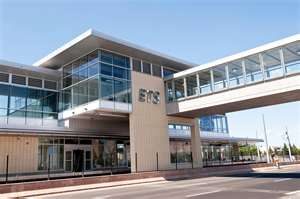
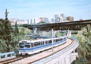
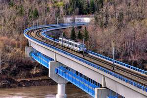
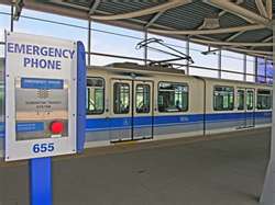
Edmonton Light Rail Transit, more commonly referred to as the LRT, is a light rail system in Edmonton, Alberta. Part of the Edmonton Transit System (ETS), the 20.5-kilometre route starts in Edmonton's northeast suburbs and ends at Century Park in Edmonton's south end. The system uses trains of either Siemens-Duewag U2 cars or Siemens SD-160 cars; 37 of the SD-160 cars were ordered between 2005 and 2007, with the first cars entering revenue service on January 27, 2009. The system currently comprises the following 15 consecutive stations: Clareview, Belvedere, Coliseum, Stadium, Churchill, Central, Bay/Enterprise Square, Corona, Grandin/Government Centre, University, Health Sciences/Jubilee, McKernan/Belgravia, South Campus, Southgate, and Century Park stations. Of these, Churchill, Central, Bay/Enterprise Square, Corona, Grandin/Government Centre, and University are underground. Plans are in place to extend south to Ellerslie station, north to Gorman Station, and a spur north of downtown to MacEwan, Kingsway, and NAIT. During construction, surface area was preserved (although costs increased) by tunnelling under the downtown core and the University of Alberta main campus. The underground portions of the LRT connect to a pedway system with links to many buildings. The LRT crosses the North Saskatchewan River between the Grandin and University stations on the Dudley B. Menzies Bridge, a dedicated LRT bridge. HistoryEdmonton was the first city in North America with a metropolitan population of less than one million to build a modern light rail system.The population was just over 445,000 when the route first started construction in 1974.It opened its first segment on April 22, 1978, in time for the 1978 Commonwealth Games. The line followed a CN right-of-way from Belvedere Station to Stadium Station (near Commonwealth Stadium), via an intermediate stop at Coliseum Station (near the Northlands Coliseum, now Rexall Place), and then continued in a tunnel under 99 Street to Central Station, at Jasper Avenue and 100 Street, including an intermediate stop, Churchill. The original line was 6.9 km long. When the line opened, fare collection was modelled on traditional rapid transit lines, with booth attendants. Low volumes of activity at some entrances led to weekend closures of alternate station entrances. In November 1980, Edmonton Transit–as it was then named–switched to a modified European-style "proof of payment" system, initially retaining the old turnstiles to issue the new receipts. Fares were now collected by automated ticket vending machines with irregular proof of payment inspectors, which permitted keeping all entrances open and required fewer staff. ,On April 25, 2009, McKernan/Belgravia and South Campus were opened as part of the south LRT expansion, with Southgate and Century Park opening on April 24, 2010. The first of the new Siemens SD-160 light rail vehicle train cars for the new extension were shipped by rail from Sacramento, California, on April 24, 2008, arriving in Edmonton on May 9, 2008 (37 vehicles in total). The LRT expansion was developed entirely at surface level with several underpasses, one at Belgravia Road and the other under 111 Street south of 61 Avenue. A short busway has been constructed from the South Campus station roughly parallel to Belgravia Road in conjunction with the South LRT expansion. The surface LRT line emerges to ground level just north of the Health Sciences Station at the University of Alberta, which opened in January 2006. From the Health Sciences Station, the South LRT line leads to the South Campus Station, followed by the Southgate and Century Park stations. Every station on the line built since 1983 has been built with full accessibility for persons with disabilities. In the late 1990s, Clareview and Belvedere Stations were renovated to include a roof and also had their platforms lengthened to allow for the use of five-car trains. 
In January 2008, Mayor Stephen Mandel announced that the southern leg will be extended further south along 111 Street to Anthony Henday Drive, and then west to 127 Street SW. There will be a station and a 1,000-car park-and-ride at the intersection of Ellerslie Road and 127 Street SW, then the LRT will continue south for another stop at 41 Avenue SW, with a possible new LRT yard in between. City council approved the route to the Ellerslie station, and for construction to begin on the park-and ride in July 2009, they have yet to announce when the station will be complete, as well as approval for the extension to city limits. Long range plans for the south line include possible extension all the way to the Edmonton International Airport and Leduc. North LRT expansion
On April 27, 2007, it was announced the city will begin detailed planning of a new LRT line that will run north from the Churchill Station, to the Northern Alberta Institute of Technology (NAIT), and beyond to north-end neighbourhoods such as Griesbach. The proposed new line would branch off the main LRT line at Churchill Station, run west along 105 Avenue to the Grant MacEwan University City Centre Campus, then north along 105 Street, Kingsway (Avenue), and 106 Street, to Kingsway Mall and NAIT. Beyond NAIT the line could possibly travel through the new neighbourhood built after the City Centre (Blatchford Field) Airport is dismantled, tunnel beneath the CN railway yard north of Yellowhead Trail, and continue further north along 113A Street, with long range plans to eventually extend the line to St. Albert. The new line has three confirmed stations: one at Grant MacEwan University (MacEwan Station), oneonKingsway (Kingsway Station), and one near the Northern Alberta Institute of Technology (NAIT Station). MacEwan Station would be located just east of the downtown MacEwan University campus, and west of the proposed hockey arena, at 104 Street and 105 Avenue. The Kingsway Station would be located on the north side of Kingsway, to the south of the Royal Alexandra Hospital. As part of the plan, the current Kingway Transit Centre would be relocated to the southeast corner of 111 Avenue and 106 Street, to provide service to both Kingsway Mall and the Kingsway Station. A temporary NAIT Station would be located north of Princess Elizabeth Avenue, on the south side of the Northern Alberta Institute of Technology's swimming pool and hockey arena (S) wing, before a permanent station is ultimately built after a long-term comprehensive land use plan of the Edmonton City Centre Airport lands are finalized. These plans would bring the LRT to the vacinity of the Edmonton Bridge Center. The city has commenced detailed planning and engineering studies so the project is ready to proceed when funding becomes available and hopes that the new line will be completed by 2014. In April 2008, Edmonton City Council approved $45 million in funding to build a tunnel under the EPCOR Tower site immediately, while it is still under construction, with the aim of saving $140 million more that would have been required to dig under the tower once it was completed. This step was taken even though the rest of the project had not yet been approved, because of the time constraint posed by the construction of the new tower. Construction on the tunnel began in August 2009 and was expected to be completed by September 2010. On April 30, 2009, Mayor Stephen Mandel announced a $210 million project to extend the LRT system by one stop (Gorman Station) to Gorman Towne Centre. The expansion beyond Clareview Station is planned to continue along the CN right-of-way to a station and park-and-ride north of 153 Avenue and Victoria Trail. Long range plans for the northeast leg of the LRT include extending it towards Fort Saskatchewan.
|